
This site uses cookies for analytics, personalized content and ads. By continuing to browse this site, you agree to this use. Learn more
 The Project Hawaii program was discontinued on October 8, 2013.
With Project Hawaii, you can develop cloud-enhanced mobile applications that access a set of cloud services and Windows Azure for computation and data storage. Project Hawaii provides the tools and services; you provide the creativity and imagination.
The Project Hawaii SDK enables you to create of applications that take advantage of research cloud services.
The following cloud services are included in the Project Hawaii SDK:
Download the Project Hawaii SDK
We are pleased to offer a new application analytics service called AppInsight to project Hawaii participants. AppInsight provides you with detailed insights into how your application is being used in the wild – who your users are, when they use your app, and how they use it. AppInsight can also tell you where the performance bottlenecks in your app are, and which features of your app are being used the most.
Best of all, you don’t have to write a single new line of code to do all this! Just run your final XAP through our instrumenter and you can start seeing usage data right away.

The Hawaii Android Software Development Kit (SDK) is intended to help Android developers use Hawaii services easily and quickly. The SDK includes client libraries and sample Android applications for the KeyValue, Optical Character Recognition (OCR), Relay, Rendevezvous, SpeechToText (STT), TextToSpeech (TTS), Translator, and Path Prediction services. Android applications use these client libraries to interact with Hawaii services. To ease development, the SDK provides the complete source code and associated Eclipse project files.
Before you can use the Hawaii Android SDK:
Download the Android development environment, which is available on the following website here.
Ensure that you have the latest versions of the following components:
The SDK uses the Jackson library for JavaScript object notation (JSON) serialization and deserialization. Download the Jackson library from the following website here.
Ensure that you download the stable 2.x version, which includes the following three files:
Learn about Project Hawaii on our Discussion Forum
Click to open Project Hawaii Discussions Forum. The forum will open in a new window.
Project Hawaii services for academic and research use sunset.
After three years of offering free mobile services for academic use, we are announcing the end of this program. You can access Bing OCR service here.
Tuesday, 8 Oct 2013 00:00:00 GMT
Win cash developing Windows Phone apps using Project Hawaii services!
Plan, prepare, create, develop, enter! Use Windows Phone and Project Hawaii to develop your vision. If your app is judged to be one of the top 3 entries, you’ll be acknowledged at IEEE CCNC.
Tuesday, 27 Nov 2012 00:00:00 GMT
Project Hawaii SDK 2.1 for Android now available
The release allows development of Hawaii-powered applications on Android platform
Thursday, 7 Nov 2012 00:00:00 GMT
Project Hawaii SDK 2.1 for Windows Store Apps now available
The release allows development of Hawaii-powered applications on Windows 8
Monday, 15 Oct 2012 00:00:00 GMT
Project Hawaii SDK 2.1 for Windows Phone 7.x now available
It includes a new SMASH service that enables ad-hoc mobile sharing. In addition, the project Hawaii can be subscribed to on Azure Data Market
Tuesday, 9 Oct 2012 10:00:00 GMT
Bahl Achieves Alma Mater’s Distinction
In Boston on April 17, Victor Bahl, director of Microsoft Research’s Mobile Computing Research Center, will be honored as one of the University of Massachusetts Amherst’s Distinguished Alumni.
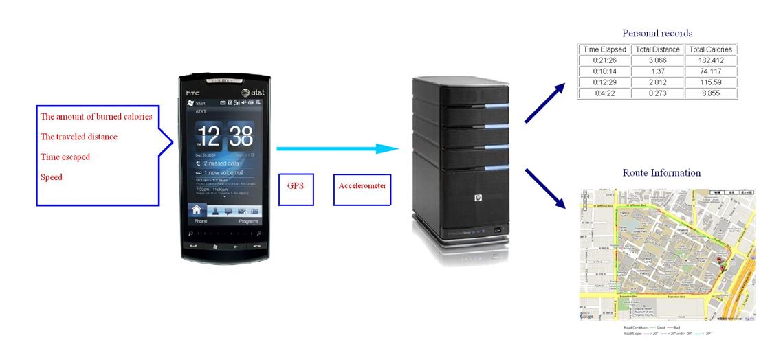
These projects use Project Hawaii services and the Windows Phone platform. The students created these projects as part of their class curriculum and explored cloud-enabled mobile computing.
Blind Helper is developed to assist people who are blind or visually impaired to identify their locations and contact with other people using smart mobile phones.
Mohamed Abd El Aziz, Karim HabakEgypt-Japan University of Science and Technology
We are constantly bogged with mundane routines at certain locations. For e.g: 1) Sending SMS to someone when we reach home 2) Setting ringtone profile to silent in movie theaters/workplace/school 3) Launching certain apps at certain locations (for e.g. bus arrival app at bus stop). Since there is a correlation between the location we are in and the lists of actions we want our phone to do, we believe that building a Location aware action triggering like IntelligentMe will change the way people use their smart phone.
David CHUA Zhi Hon, George HE Shuxian, Jayson ANG, QIU YuchunSingapore Management University, School of Information Systems
ReceiptManager provides you the ability to consolidate and view the digital receipts generated by your various mobile payment applications in one single location. With ReceiptManager, you can easily review your mobile expenditure history, as well as have the ability to track the geographic trail of your mobile monetary transactions via Bing Maps.
Singapore Management University, School of Information Systems
Convo is a chat mobile app with a social networking essence. Its main features include: One-to-one and group chat transfer, which has been implemented using the Hawaii relay service, local caching of chats and preservation of an exclusive chat context for each conversation. Special attention was given to the user interface, while also the application functionality has been enhanced, with features such as the Locator, to offer a better alternative to existing chat applications on Windows Phone 7.
Siddhartha Gupta, Ronald Searl and Suraj Modi University of Illinois at Urbana-Champaign
Verto is a mobile app that promotes non-monetary trading. Individuals can use the application to publish items that are willing to trade in the exchange of other items. In terms of implementation, speech to text integration is supported for most application features and an intuitive user interface has been designed for Windows mobile phones. The interaction with the Windows Azure cloud services is based on the client/server model and user authentication supports the use of Facebook accounts. On the cloud the WCF service is used to utilize the SQL Azure database.
Aviral Jain, Pranav Ram and Tej ChajedUniversity of Illinois at Urbana-Champaign
Eventeè is an event sharing mobile application. Close integration with Facebook has been implemented, for user authentication as well as events publishing. Bing maps and directions are used for the events. Users can invite other users to specific events and also receive event notifications and reminders. In the cloud the applications uses Windows Azure cloud services, specifically WCF data services, Open Data protocol and Binary Large Object (Blob) storage. Concerning future work, the implementation of an event suggestion algorithm is under consideration.
Fabian Becerra, Kevin Hsu, Gaurang Katyal and Taehwan KimUniversity of Illinois at Urbana-Champaign
Classelect is a mobile app that targets to facilitate course selection out of a university curriculum and is based on three principles: Requirements (of the curriculum), Reviews & Ratings (of classes, professors etc. by students), and Recommendations (for classes you could//should take). Let’s face it, those generic course descriptions on college websites are just not enough. You don’t get to know enough about the material, nature, usefulness, the professors or just about anything about the class. If you’re lucky, all you learn is about the topics covered. These descriptions become even more important when you have multiple classes, or potentially, multiple career paths to choose from. With Class Select we aim to empower students, of any sort of education institution, to learn more about these classes they are about to take from students who have “been there, done that.” Not only can students learn about what other students think about various classes & professors, but they can also share their experiences with their peers. The app comes with some handy features which are motivated by the principles of web 2.0 and collective intelligence. Granted, there exists a fragmented market of such tools on the web, but such an idea, or app, to our knowledge does not exist on mobile platform yet. And since the future is going to be “mobile,” there exists the need for such a tool for students, who are one of the most technologically active groups nowadays.
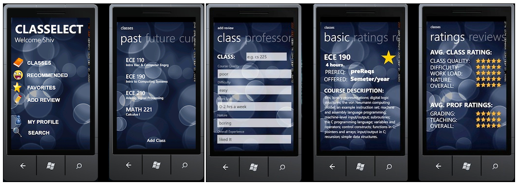
Devbratt Harlalka, Zeqing Li and Shivam SharmaUniversity of Illinois at Urbana-Champaign
In recent years the Restaurant Industry has begun catching on to the new wave of technology and social media outlets available everywhere. A few groups, such as OpenTable and GrubHub.com, are trying to capitalize on this new wave by providing a means to make reservations from your phone or by providing an interface to order online. However, the in-restaurant experience has been entirely static for years and years, even though there are some key weak points that could be improved with a little more technology. Our mobile and web application, GOUR, is a way to drastically improve the ins and outs of the restaurant experience. With GOUR, you can search for, make reservations for, and see all the reviews for the restaurant of your choice. Once you have made your choice, using GOUR, you can pre-order your meal, days in advance, so that it is ready once you and your party arrive. Then you can amend your order, call for service, and even pay, all using GOUR. Our platform makes it easy for the restaurant to schedule reservations, see which tables have which customers and which orders, and track which parties need assistance (for more water, or ranch dressing). With GOUR, going out to eat is a smooth and painless experience where all of the resources you need are in the palm of your hand!
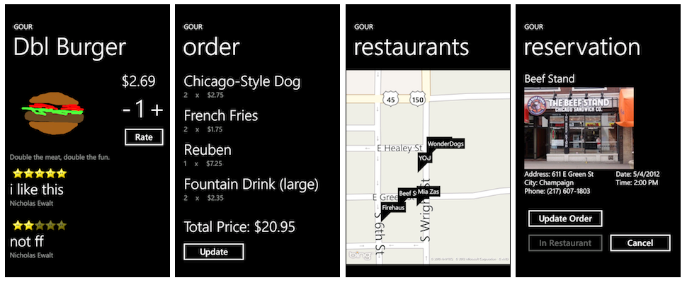
Caleb Qian, Nicholas Ewalt and Justin MartinUniversity of Illinois at Urbana-Champaign
Drivers always face situations in which they drive on roads that they are not familiar with. Driving on unfamiliar roads makes the driver a good candidate of accidents especially in night trips. Many accidents happen on specific and known spots on the map over and over again due to the same reasons as in some areas people are driving so fast, not paying much attention to the road signs or the road nature. If you know ahead about these road issues, you’d drive safer and smoother than ever.
In our solution to this problem, We are targeting vehicle drivers. We deliver notification about what will driver face soon next on roads (about potholes, bumps, congestion, road exits, accidents, U-turns, etc..). Those notifications are precious for drivers to take their precautions before ahead facing those situations.
Eslam Ashraf and Muhammed ElsayedEgypt-Japan University of Science and Technology, Egypt
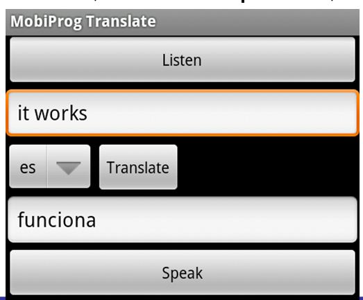
TRANSLATR is a utility for on-the-go translations. Visual, audio, and text inputs are used for various methods of translation. Project Hawaii’s optical character recognition and speech-to-text services are used for visual and audio inputs, whereas the Bing Translator API is used for textual translations.

Jason Bussard University at Buffalo, SUNY
A location based music sharing application built for the windows mobile platform with an element of a social application. Music Bomb is a LBS (location based service) Windows Phone 7 app built as part of Microsoft’s Project Hawaii. It is a music sharing application along with social networking capabilities. Users can share their favorite music with fellow users nearby. These users can make new friends with the people from the surroundings With the social network feature, user can also make new friends who are inclined to the same style of music, even meet in real life and talk more.

Vivek Nandavanam and Wei Zheng University at Buffalo, SUNY
We developed an information sharing service with respect to location. In this system, a user provides information to the system, also it provides metadata about the same information. This information will be shared with users having same preferences as metadata, location until some threshold time limit. We used terms tagging, location-tweets, and threshold time limit for metadata, shared data and TTL respectively.

Naveen Rawat and Vikram Sawant University at Buffalo, SUNY
Data Silos are a threat to the openness of the web and hampers the potential benefits of the free flow of information (often referred to as Linked Data or the Semantic Web). The modern smartphone is an example of a Data Silo, but there are legitimate privacy concerns with allowing personal data from a smartphone device to be freely accessible. Existing solutions for making personal data on a smartphone more widely available do not currently meet the needs of a Linked Data architecture. In this paper we describe how to securely expose personal Linked Data from your smartphone device to authorized 3rd parties using the OAuth protocol. A proof of concept architecture OAuth based architecture tackles the 3 primary data silo challenges of Duplicated Data, Ad-hoc Integration, and Data Migration. The architecture includes a OAuth 2.0 server component that is connected to a mobile device via a cross-platform mobile application utilizing Phone Gap technology. We evaluate this architecture and prove it to be effective. We show that highly valuable personal information that is locked within a smartphone can be shared in a secure way on the Semantic Web.
Matthew MarumNorth Carolina State University
Nilesh Mishra, Luis D. PedrosaUniversity of Southern California
Joongheon KimUniversity of Southern California

Bin LiuUniversity of Southern California
Gaurav Sanghavi, Nirmit DesaiUniversity of Southern California

Anupama Mann, Sagar KapareUniversity of Southern California
Phone dynamically creates your “business card” containing information about you selected appropriately for the surrounding context.
Bao, McDowell, TorskiDuke University

Weiwei Chen, Shuo ZhaoUniversity of Southern California

Kai Song, Chengjie ZhangUniversity of Southern California

Moo-Ryong RaUniversity of Southern California
Bo-Chun WangUniversity of Southern California
Find a date local to you who matches your profile and interests.
Andryieuski, Olien, TanumihardjoWisconsin-Madison
Assist people with speaking disabilities by enabling them to navigate a menu of words on a phone to construct sentences.
Jenkins, Liu, SuskiWisconsin-Madison
Leave virtual sticky notes in different locations and interact with others seeking similar information at a given location.
Ilikhan, Liao, MeyerWisconsin-Madison
Leave virtual sticky notes in different locations and interact with others seeking similar information at a given location.
Yin, Li, Kebyl, FlemingDuke University
Ringtone is modified on the fly to contrast with ambient noise in the current location.
Lin, GonzalesDuke University
MYSCIENCE is a free mobile app that enables individuals with smart phones to contribute to a variety of science research projects by gathering useful information using the sensors on their phones. The data is then made available in aggregate, on the cloud, to scientists.
Naran Bayanbat, Lu Li, Forrest Lin, Mike Ortiz, Vignan PattamattaStanford University
Blind Helper is developed to assist people who are blind or visually impaired to identify their locations and contact with other people using smart mobile phones.
Mohamed Abd El Aziz, Karim HabakEgypt-Japan University of Science and Technology
Classroom7 is a cloud-enabled mobile application for the purpose of enhancing the learning process by adding more interaction and collaboration between students. Classroom7 is implemented using Windows Phone 7 and Windows Azure Cloud Computing Platform.
Moustafa Alzantot, Mohamed HatabaEgypt-Japan University of Science and Technology
Traditional character passwords are difficult to remember and vulnerable to attacks from unauthorized users. We have created a method of password authentication using multiple representations of categorized pictures instead of a string. This method of authentication, named PictureLock, is incorporated into an application, named Security Organizer, that stores information for online accounts. PictureLock provides countermeasures to known access control threats.
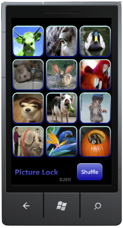
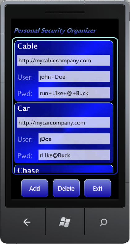
David Chuha, Sarah Honacki, David Kronk, Marc Mustric, Peter TefftOhio State University
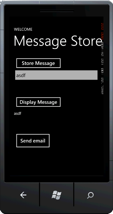
This project aims to explore the feasibility of information leaking on the Windows Phone 7 platform. The project stores a user-entered message on a Windows Phone 7 and collects the device ID and user’s geolocation, which is then emailed to a remote recipient. Students discovered that, thanks to Microsoft’s security architecture, information leaking is difficult to achieve on the platform without attracting user attention (and suspicion).
Desteban Escobar, Greg Landrum, Darwin ThomasOhio State University
Network administrators need a simple, low-cost solution that allows them to monitor their wireless networks in real-time at any time, from anywhere. Furthermore, network administrators have varying needs as to what metrics to gather from their network, and when to use each metric. In this work, we develop a proof-of-concept system that addresses these points. Our system consists of a Windows Phone 7 application which displays real-time information via polling a wireless network sniffer application for results on arbitrary metrics. We show that, upon further optimization, our solution is viable for use by network administrators in practice.

Daniel Vucci, Jesper PedersenUniversity of California Santa Barbara
Human eyes have a limited range during each eye fixation. As a result, searching specific text in a document or an image is time consuming. In this paper, we design QUEST7, a real life search agent combining the advantage of mobile devices and cloud computing. Utilizing Optical Character Recognition (OCR) service provided by MSR Project Hawaii, we extract texts from images captured on a mobile device. Keywords are then highlighted for human use. Experiments show that QUEST7 is significantly faster and more accurate than human eyes for dense texts. Extensive measurements are carried out to identify sources of delays in the process. With 3G access, network transfer latency tends to dominate. In contrast, OCR on the cloud side contributes to most of the delay with Wi-Fi access. Presented at Mobisense 2011, June 12, 2011, San Francisco, CA, USA.
Eshwar Rohit Pedamallu, Hien Nguyen, Sushil Joshi, Rong ZhengUniversity of Houston
This app is functionally a multiplayer game which is much like Worms, a turn based game where you need to wipe out another team by shooting projectiles at them. The basis of this game is two people are placed in an “arena” where they have to destroy the other team (consisting of two characters which are controlled by a single person). They then take turns moving their characters around and at the end of their turn they fire a projectile. They take turns at this process until the one’s team is completely destroyed. At this point, the game starts up with a main menu and you are prompted to join a game. After joining the game, the player needs to type in a game name which needs to match the player with whom you want to play against. The players are then put into a match against each other. As long as one has Wi-Fi activated and connected, one can play the game; otherwise one is not able to play the game. The reasoning behind developing this app is that small gimmick games are very popular, such as Angry Birds, Tiny Wings, and Fruit Ninja. This game is meant to entertain a person while they have a few minutes to waste.

Shaobo Gu, Joshua WisniewskiUniversity of Illinois at Urbana-Champaign
Our project this semester is in collaboration with researchers at the Nation Center for Supercomputing Applications. It is essentially a system to enable personalized localized situational awareness by integrating heterogeneous sensor information. One might view it as Foursquare except that it is for emergencies. The basic premise is as follows: If you see an emergency before you or if you know of one happening nearby, you can quickly tweet about it and through the built in twitter plug in and it gets registered as an official tweet in your account. That information is then taken and overlayed onto Bing Maps; which any user with our app can view and see the exact location(via pushpins) that the incident occurred at and the detailed tweet associated with it. The user also has the option of viewing different layers on the map, in the event that they are looking for a specific type of event. Another important functionality is a slider that allows the user to view the change of the spatiotemporal animation on a map interface for heterogeneous sensor streams including OGC Web Mapping Services and citizen sensing twitter feeds. Each position of the slider corresponds to a time range (e.g. last 30 minutes, last 24 hours) and this allows the user to see all tweets that were posted within that time range as well as the weather radar information. We believe that with this as a basic premise, we have a prototype that could potentially be a very successful app, that people would use in the event of an emergency and would therefore get help warn others about the exact location and nature of the emergency.


Sahil Handa, Adarsh Hasija, and Pratch PiyawongwisalUniversity of Illinois at Urbana-Champaign
One of the biggest problems people face when travelling is a personalized planner. This Windows phone application combines data from Facebook, Bing, and Yelp to provide personalized planning and recommendation to users while travelling. Features of the application can be found on its weburl including, History aware plans and Budget Aware plans.
Sultan AlfarhoodUniversity of Arkansas
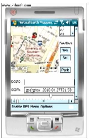
Park Manager helps drivers to find nearest parking spots for their vehicles at nearest available parking areas. Also Park manager manages parking areas that are participating in the system.
Sameh Abo SamraEgypt-Japan University of Science and Technology
CSE 481M worked on a set of home automation projects using the Project Hawaii Platform and the Microsoft Research HomeOS.
Home Networking Capstone, University of Washington, CSE 481M
This project encrypts SMS messages sent from one person to another using a four-digit symmetric key (PIN). The sender enters the message and the PIN; the message is XORed with the PIN. Any eavesdropper only sees meaningless gibberish.
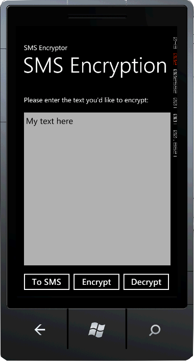
Patrick Mulac, Jason Carrier, Jacqueline Telljohann, David Reing, Daniel SpagnuoloOhio State University

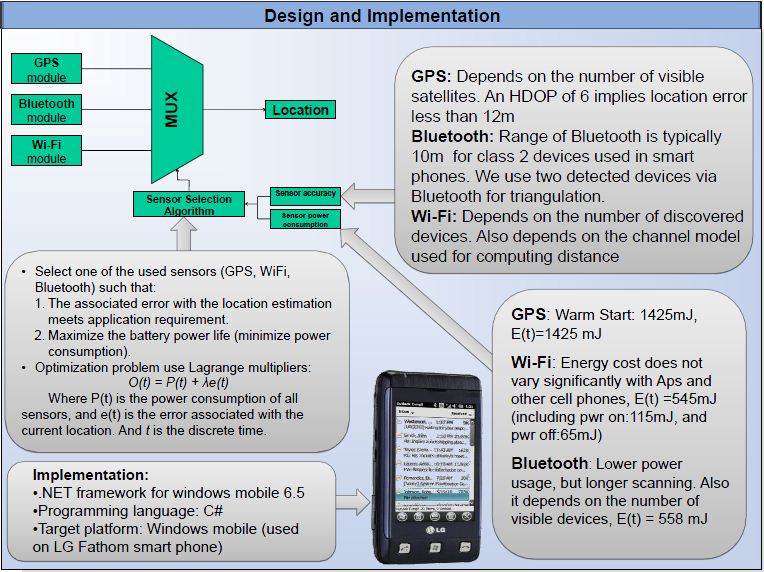
Location-based smart phone applications like social networks, traffic information, health services, food services, entertainment, etc., are becoming increasingly popular, especially that GPS functionality is becoming a standard in new phones. However, GPS is a power hungry service, and using it as the only location service will quickly drain the phone’s battery especially if users need continuous updates from location-based applications. Moreover, GPS accuracy degrades in urban areas where tall buildings are present, and where the user needs accuracy the most. We propose and implement an energy-aware and accuracy-aware system that utilizes other common functionalities available in a smart phone, specifically: Bluetooth, WiFi, and accelerometer, to provide location information service that could be used by location-based applications. In Bluetooth, a smart phone device requiring to update its location information can scan nearby devices, and obtain the locations of those devices. Due to the relatively short range of Bluetooth, the device can safely copy the acquired location to be its own, and assign a 10m uncertainty on it. When using WiFi, by creating a network with nearby anchor nodes, the position of the device can be determined on triangulation basis. The accelerometer can predict how and where the device is moving, and using this data, the next position of the device could be estimated. Bluetooth, WiFi, and accelerometers require less power than GPS, but they provide varying accuracy depending on a user’s location. For example, WiFi would be more accurate than GPS in urban areas due to the high density of access points, and other people owning mobile devices. An investigation of the power consumption and accuracy of each of the four mentioned technologies will be made. An algorithm will be implemented to dynamically select the proper technology for the location service based on the input of the required accuracy, the detection of the current battery level, and the user’s setting for the battery quota provided for location-based applications. A Bayesian estimation framework will be used to model the investigated accuracy, and the available power, which can then be contrasted with the input requirement.
Salim Mohamed, Reza HajisheykhiMichigan State University
We propose to overhaul the current authentication system used on UIUC’s campus and automate and integrate other tasks such as room scheduling with our system. Our architecture proposes an innovative multi-step authentication approach to this problem so as to get around single point of failure. Given the proliferation of GPS enabled smart phones, each user in our system can be identified by their personal smart phones. The GPS within cell phones can authenticate that the given user is indeed within the building. Authenticating whether the user is indeed by the resource or a room to which access is being demanded however is non-trivial. We use QR codes as the second layer of authentication in our architecture for this purpose. The user can use the camera on his mobile phone and take a picture of the QR code and thus authenticate his presence right by the resource. This QR code is decoded and the string is sent to the cloud which then authenticates the user and could then unlock the resource for the user.
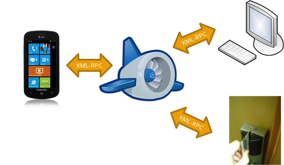
Amey Chaugule, Joe Fernandez, Abhishek PradhanUniversity of Illinois at Urbana-Champaign
WiPAX is a chat client developed for Windows Phone 7. The client is built on the Extensible Messaging and Presence Protocol (XMPP), an open-standard communications protocol used by Google Talk, Jabber, and other chat providers. The ubiquity of XMPP allows WPAX users to communicate with any other users on the same protocol that have authorized them. Of particular interest, is Google Chat which has been adopted by a large number of users. We were able to find only one, poorly rated application on the Windows Phone 7 marketplace that offered Google Chat support, which was clearly still in the early stages of development. WPAX is a fast, simple, stable, easy-to-use alternative.
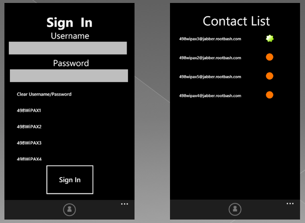

Henry Beberman, Tomasz Kalbarczyk, Brian PatzinUniversity of Illinois at Urbana-Champaign
We are constantly bogged with mundane routines at certain locations. For e.g: 1) Sending SMS to someone when we reach home 2) Setting ringtone profile to silent in movie theaters/workplace/school 3) Launching certain apps at certain locations (for e.g. bus arrival app at bus stop). Since there is a correlation between the location we are in and the lists of actions we want our phone to do, we believe that building a Location aware action triggering like IntelligentMe will change the way people use their smart phone.
David CHUA Zhi Hon, George HE Shuxian, Jayson ANG, QIU YuchunSingapore Management University, School of Information Systems
ReceiptManager provides you the ability to consolidate and view the digital receipts generated by your various mobile payment applications in one single location. With ReceiptManager, you can easily review your mobile expenditure history, as well as have the ability to track the geographic trail of your mobile monetary transactions via Bing Maps.
Singapore Management University, School of Information Systems
DaySaver shows exactly where the rain is and suggests what to do when it is raining.

Singapore Management University, School of Information Systems
Network Forecaster allows a user to query details of network (WIFI or 3G) and read reviews (bandwidth, signal strength, etc) left by other users who used a particular network and left comments. It also allows user to leave comments about a network for other users to see.
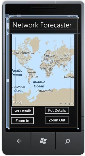
Aditya Pabbaraju, Srujankumar Puchakayala, Preeti PillaiUniversity of Michigan
The application collects ECG and EKG data from our inhouse nanosensors sensors over Bluetooth. The application works in two modalities. It can display realtime ECG data on the mobile phone screen and it can relay data to our backend server. The data sent over to the backend is geo-tagged. The data at the backend server is stored in a mysql database. The data and the location of the patient is displayed on a web based portal.
Prashanth Shyamkumar, William WilkinsUniversity of Arkansas
We are developing a zombie based game where users can infect each other when they are physically proximate. Every user of the application uploads his latitude and longitude to a central database and a script resident on the server finds users that are close to each other. The webserver resident script notifies users devices of the phones that are close to it.
Christian WilliamsUniversity of Arkansas
MobiSafe is an application that uses the Microsoft Hawaii GPS Wrapper, Skype4COM API, and a neural network service running on a server. MobiSafe is used to detect whether a driver is in a danger zone. Every driver offloads his location and speed to the server and the neural network engine and uses other input parameters (such as the number of past accidents around that location and the number of red lights around that location) to decide whether the driver is in a danger zone. Then the application intercepts an incoming call and reroutes it back to the caller, notifying that the driver is in a danger zone. By using MobiSafe, drivers are safe from being distracted by incoming calls. Also, it lets the caller know that the driver is driving and in a danger zone.
Tri NyugenUniversity of Arkansas
The idea is to build a phone application running on Windows Phone 7 to locate friends based on GPS coordinates: users can search for friends, know where they are and what they are doing. The application also allows users to find friends to join themselves in a certain setting by creating an event. The user can simply invite all his friends to the event and wait for their reply. With just a few clicks of the button, anyone can connect to their friends wherever they are.
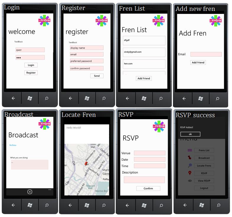
Angeline SU Peishan, LAM Yan Yee Cindy, TAN Kuan Liang, TSANG Wing HeiSingapore Management University, School of Information Systems
LunchBox allows you to instantly set up lunch appointments with group of friends in seconds, map to show current location of all attendees and maps to show restaurants that are nearby and also user defined location. It also allows instant status update about each other for all attendees and Push Notifications sent to each other.

Subeesh Basheer, Skye SimSingapore Management University, School of Information Systems
Flagged Down is a mobile application that aims to allow users to search and hail cabs within their vicinity.

Alex Chng, Hendry Poh, Nicholas Szetoh, Tan Jun Ming, BevanSingapore Management University, School of Information Systems
Photo-Location Service allows users to store photos and locations to the cloud and then retrieve photos that were taken by other users near the location of the current user. Our Photo-Location service involved two parts: the server and the client. We leveraged the Windows Azure Services and Project Hawaii in this homework project. The two services we used were Location and Storage.
Alex Crowell, Michael ChowUniversity of Michigan
The goal of this application is to minimize the energy consumption of localization using a GPS unit. The project uses an accelerometer to augment a GPS unit on a Windows Mobile phone. We are developing a HMM based algorithm to convert raw and noisy accelerometer readings into meaningful distance measures. Using an adaptive algorithm, our system will determine when to switch on the GPS unit such that accuracy is within acceptable limits (as determined by the application)—when the GPS unit is off, location is inferred from the accelerometer.
Haibo ZhangUniversity of Arkansas
In this application, we use geo-tagged images taken using the windows mobile phone to generate 3D models outdoors and indoors. The mobile phones takes GPS annotated images outdoors, and accelerometer annotated images indoors and transfers it to back-end server. The backend server runs a clustering algorithm, an image stitching, and consequently a 3D model generator to generate 3D models of indoors and outdoors. Although not supported by the application yet, these models can be used to augment street views of Google Maps. The major advantage of the system is that it provides temporal consistency—the models are updated frequently based on how often pics are uploaded to the server.
Anirudh LadhaUniversity of Arkansas
The goal of this application is to collect data on important contexual information that can be used to build a personalized search engine for mobile phones. Personalized search refers to building user specific models and augmenting search queries with additional information specific to the user. Such a search engine on the phone can help minimize the number of unnecessary results retrieved from the backend search service like Bing or Google. Our application profiles data on web browsing history, search history, location, to-do and calendar items. We plan to use the collected data to study the efficacy of personalized search.
Chris GaetelyUniversity of Arkansas
To test and deploy your applications on an actual device, you will need to get an App Hub membership to unlock a phone. Students may register for a one-year free membership. You need to complete all the steps below to unlock a phone for application testing.
Step 1: Verify as a Student with DreamSpark
Step 2: Begin App Hub Registration

Step 3: Submit an Application (to start GeoTrust verification process)
Note The purpose this step is to submit a test app to get the GeoTrust process started. The app you submit in this step does not need to be published in the Marketplace. You can withdraw it before that happens.
Step 4: Identify Verification with GeoTrust
Step 5: Unlock the Phone to Deploy Applications
Follow the MSDN how-to instructions, or follow these instructions:
Now you can deploy applications on the phone and test them (any application, not just the one you submitted to kick off GeoTrust verification above). In Visual Studio, click Windows Phone 7 Device instead of Windows Phone 7 Emulator as the target. Your app runs on the phone. Have fun!
These resources provide a more in-depth look into Windows Phone application development.
Forums
Documentation
Tutorials
Books
Downloads
You can submit your completed application to the Windows Phone Marketplace throught App Hub. Students may submit a limited amount of apps free of charge (see the App Hub FAQ).
Project Hawaii provides project participants with access to Windows Azure for use in creating their own cloud services. Windows Azure is Microsoft’s cloud services platform, and provides computation, database and other capabilities hosted in the cloud.
Use the Windows Azure toolkit for Windows Phone 7 to build Windows Phone 7 applications that take advantage of cloud services running in Windows Azure.
Learn more:
There are MSDN community support forums for Windows Azure, SQL Azure, and App Fabric.
The Windows Azure Toolkit for Windows Phone makes it easier for you to build mobile applications that take advantage of cloud services running in Windows Azure. This toolkit includes Visual Studio project templates for Windows Phone and Windows Azure, class libraries optimized for use on the phone, sample applications, and documentation. All this content is designed to be easily reused, simplifying your experience and optimizing your time when building your own phone applications leveraging cloud services.
Microsoft offers many of its professional development tools and other software to students at no charge on the MSDN Academic Alliance and Microsoft DreamSpark programs.
The available tools include Visual Studio 2010 Professional edition, which in comparison with the Express edition, includes more features and also allows for extensibility add-ins and external tools. As one example, programmers who are familiar with the Emacs text editor on other platforms will likely appreciate the Emacs Emulation extension.
In partnership with universities around the world, Project Hawaii enables students to develop inventive cloud-enhanced mobile applications. Students at participating universities can use Windows Phone for accessing a set of innovative cloud services and Windows Azure for computation and data storage.
Interested in using Project Hawaii in your teaching? Send us your proposal.
Find curriculum resources, to use in your classroom.
Courtesy Prof. Rajesh Balan, Singapore Management University
Understand the basic definitions and technology of mobile and pervasive computing. Understand the various terms used in mobile technology and have a sense of what they mean and how they are applied.
Understand the challenges associated with location detection. Represent location information on a global map and find location of other people. Get an insight into the issues of privacy and security associated with location sharing.
Courtesy Prof. Nilanjan Banerjee, University of Arkansas
Why and What of Mobile and Pervasive Computing?
Where am I: Localization?
How do I get data over the air: Mobile and Wireless Networking?
Using Resources in the cloud: Cloud Computing in Mobile Systems and applications
Damn! Why does my phone die when I need it most? Energy Management?
There is a natural synergy between mobile devices and cloud services:
Project Hawaii enables you to develop inventive cloud-enhanced Windows Phone applications.
BACK ROW (left to right): Gleb Krivosheev, Philip Fawcett, Ronnie Chaiken
FRONT ROW (left to right): Arjmand Samuel, Jitu Padhye, Alec Wolman, Victor Bahl

(left to right): Casper Liu, Jun He, Li Zhao, Hua Li, Xin Peng

Can I use the Hawaii SDK for academic and research projects?
Yes, you can use the Hawaii SDK for research, teaching, and other academic uses, free of charge. It can however not be used for any commercial applications.
How do I get in touch with Project Hawaii team?
Send email to hiforum@microsoft.com.
Does Project Hawaii have a Facebook page?
Yes, find us on Facebook. Click Like on our page and receive news updates from the Project Hawaii tea.
Does Hawaii Relay Service support relaying text messages or can it also relay images and other media?
With the Hawaii Relay Service you can relay any bits you like, not just text.
Is there any documentation for the Project Hawaii services?
Yes. See Project Hawaii Documentation.
